


How Phillips and surrounding South Minneapolis communities continue to be burdened with traffic-related air pollution
By H. LYNN ADELSMAN
Many statements and studies exist to promote that East Phillips deserves to be a “Green Zone” and the Minnesota Pollution Control Agency (MPCA) confirms there are multiple negative health effects from air pollution worse in the central city. Yet for over 5 years the city continues to push for an expanded public works department storage and maintenance facility with over 100 diesel vehicles to replace the Roof Depot site in East Phillips. Why is there no effort directed to place this facility in the western or southern most neighborhoods of Minneapolis? This will increase traffic in Phillips and the surrounding communities to further add to existing high emission levels harmful to residents.
The concentration of high traffic related air pollution (TRAP) in communities where there is less private property ownership and low equity in housing / wealth has a history in Minneapolis. In 1956, the National Interstate and Defense Highways Act created plans for 35W”™s Southside path with no community input but from white homeowners. In the 1950s, as 3Ww plans were laid out, with Lyndale Avenue being the most logical route, Lyndale residents resisted and 35W was rerouted through the redlined south-central African American community.
In a planning report prior to eminent domain takeover of homes entitled Freeways in Minneapolis by Barton and Associates, they described how there were no “unified and strongly functioning groupings” or “viable communities” in the pathway where 35W would be built. So it should be no surprise then that planners today would not see and value the families that are not majority-white who live in East Phillips. Less than a mile away is Little Earth, the only Native preference Section 8 housing project in the nation.
In 2013, a seventy page City of Minneapolis Environmental Justice Working Group Climate Action Plan recommended support for “increased funding opportunities for low-emission infrastructure. Green Zone designation would ensure that communities most highly impacted by environmental hazards and economic stressors receive much-needed resources and support.” This supports the plan the East Phillips Neighborhood Institute (EPNI) has created for the Roof Depot site to host an indoor urban farm project, affordable housing, urban food production, a coffee shop and a bicycle shop on the seven acre site.
In January 2020, a University of British Columbia at Vancouver study confirmed that there are associations between road proximity and impaired cognitive function and neurological disorders drawing a definitive connection between Alzheimer”™s, dementia, multiple sclerosis and Parkinson”™s to living near major roadways and freeways. Add this to the existing list of health effects from traffic related air pollution (TRAP) that includes cancer, cardiovascular and respiratory diseases (ie: asthma). To counter these negative health effects the study suggests spending time in green space. Which there is little of given the many high traffic roadways in Phillips such as Hiawatha, Cedar, Lake, 26th and 28th streets.
East Phillips historically has held many commercial and industrial properties which continue to pollute air, soil and water. This includes air pollution from the Smith Foundry & Bituminous Roadways, contaminated soil from lead from high traffic and arsenic from Reade Herbicide manufacturing plant, and groundwater contamination into underground aquifers per the Minnesota Department of Agriculture.
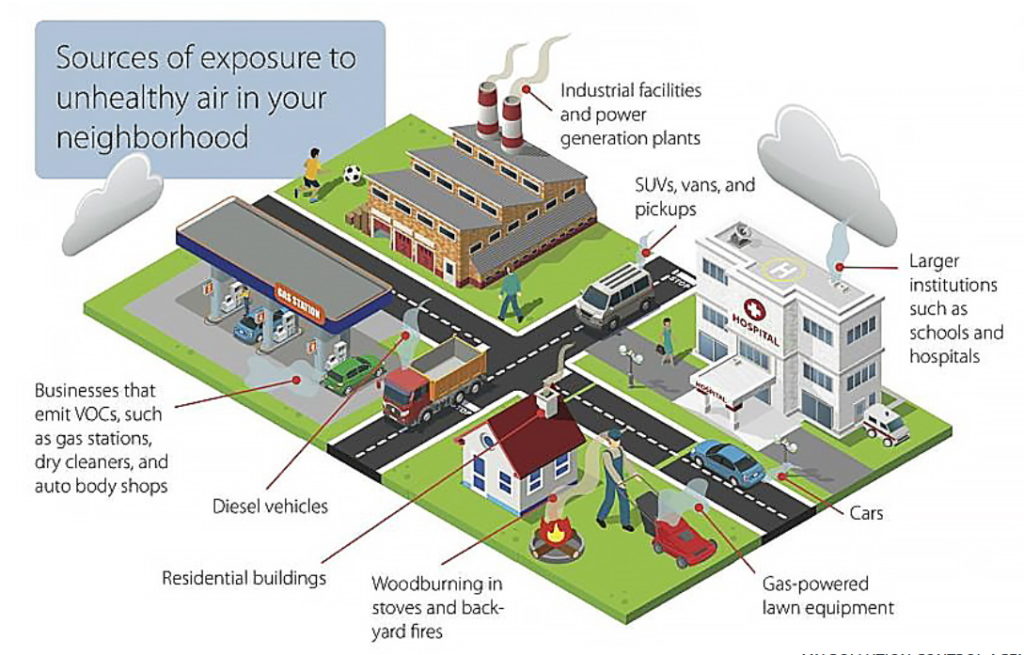
The MPCA notes regarding “Vehicles and equipment, pollution from vehicles is an important environmental justice concern. A 2015 study by MPCA researchers found that while communities of color and lower socio-economic status tend to own fewer vehicles, do less driving, and use public transit more often than other groups, they are also exposed to higher levels of traffic-related pollution. This is because busy roadways and the associated air pollution emissions, often run through communities of color. Many communities of color therefore bear a disproportionate burden of traffic-related health impacts while contributing less to vehicle pollution.” Such “busy roadways” in East Phillips already exist and adding the public works storage and maintenance facility site will further increase diesel vehicle TRAP.
Spending thousands of dollars, if not more, for years to research, study and announce that there are notable negative health effects requiring a Green Zone label in East Phillips are meaningless without infrastructure change. Many of us and our neighbors are not well where we live. Cancers, heart disease, stroke, asthma, and now neurological related diseases are seen in infants to elders, beginning at unusually early ages. It is past time to listen to the people who live in Phillips and support a healthier community within. And recall the wind does not blow in one direction only, carrying this TRAP into Phillips alone.
H. Lynn Adelsman is a community historian who focuses on public health, housing and school history in Minneapolis.