


")


Diagonal Pedestrian Paths with Mary Ellen Kaluza
By MATTIE WONG, Radicle Land Collective
The purpose of Phillips Imaginary is to consider alternatives in our built environment from the minds of residents, whether or not they would ever be considered in reality. You can’t build or debate what you can’t imagine, first!
In this inaugural article, Radicle Land Collective talks to Mary Ellen Kaluza, a long-time Phillips resident, about diagonal cut-throughs to aid pedestrian movement in our very gridded city.
The midwestern grid we are so familiar with was devised by Thomas Jefferson during the late 1700s when various purchases of land were made. The grid was seen as an efficient way to survey and parcel out the land in order to be sold off and settled to fund the then-young US government. Gridded American cities generally followed this logic – the grid is a geometrically efficient shape for city services, bus lines with fewer transfers, and maximizing building space. Some would argue it sprang out of puritanical ideas of social order and neatness. Various other ideas of urban street design have existed in the past and are changing even now in the present. Many European cities were built radially from the center, in order to be more defensible in war. Cul-du-sacs and sprawling suburbs that concentrate residential and commercial areas in our recent era have greatly changed the logistics of living.
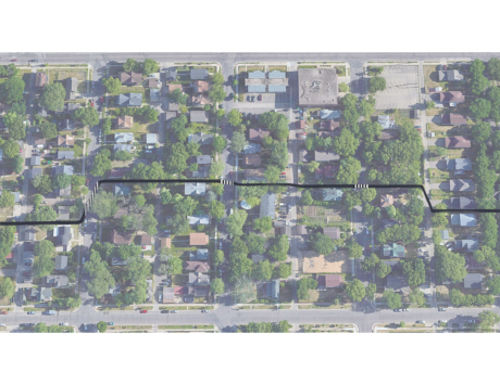
In Minneapolis, our grid system creates blocks that are .1 miles N-S and .05 miles E-W, on average (the grid shifts 45 degrees in the Downtown and Marcy Holmes neighborhoods, in orientation to the river). When walking, to get to one corner of a block to the opposite corner would be a distance of .15 miles. If there were diagonal pathways for pedestrians across the city, this could be reduced to .11 miles per block. Of course, this would have rippling effects, such as changing where buildings could be built and the size and shape of alleys and backyards. Mary Ellen Kaluza specifically talks to us about why this could boost walking in the neighborhood.
Radicle Land Collective: What is your idea?
Mary Ellen Kaluza: Incorporate more pedestrian-friendly walking infrastructure into urban design. We are stuck on this right angles grid pattern that is terribly inefficient. And unnatural.
RLC: What inspired this idea?
MEK: I’ve lived in the Phillips community for nearly 44 years. And I have worked in Phillips or nearby for the vast majority of those years. I walk most of the year to and from work. (I confess to cheating in the summer by riding my bike – it lets me stay home for a few more minutes). I choose medical providers based on whether or not I can walk to them. I describe distance in how many minutes it takes me to walk there.
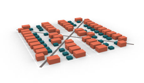
Red represents housing, blue garages, and dark grey the diagonal pathway. At this scale, you can see how lots shift in size and shape, creating interesting interfaces between public and private spaces.
RLC: Why do you think it would help the neighborhood?
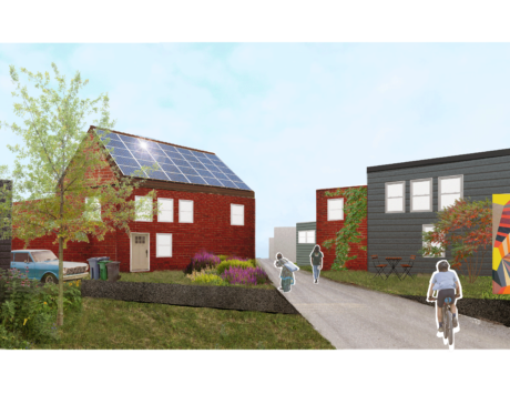
MEK: I often felt irritated by having to walk all the way to a corner when a diagonal shortcut was more direct and appealing. It occurred to me that there isn’t a creature on this planet that travels at right angles. Diagonal routes could encourage more walking to places we need to go. It can save time, boost moods, provide free exercise, and make the neighborhood feel safer with more people walking about. I can imagine creative landscaping and public art being incorporated to enhance the trip to work, the library, the grocery store, your sister’s house…
RLC: Is this something you think could actually happen? Why or why not?
MEK: It would be hard to transform the rectangular grid we have built around. But there are certainly areas where diagonal shortcuts can be immediately added: public areas like parks or government property, parking lots, commercial properties, and maybe even private property. New construction and developments should prioritize walkability, not parking spaces or fences. It wouldn’t require much imagination. Many trails have already been blazed by those refusing to go at right angles.
RLC: Will it cost money?
MEK: Yes. Will it be worth it? I certainly think so.
RLC: Finally, Who are you?
MEK: My name is Mary Ellen Kaluza. I live in the Ventura Village part of Phillips and work in the Phillips West part. I routinely cut corners on my walks wherever I can! And crab about those corners I can’t cut. (Full disclosure – I do own a car but it spends most of its time in the driveway, where cars should be most of the time).
Radicle Land Collective is a landscape design/build firm interested in the land we have in common and our collective stewardship of it. Have an idea for ‘Phillips Imaginary’? Send us your thoughts at:
radiclelandcollective@gmail.com.